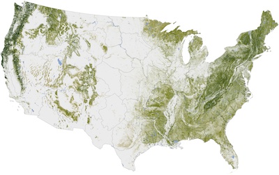
NASA maps tree cover in the United States
January 16, 2012
By
David Manly
 Jan. 16, 2012 - The NASA Earth Observatory has released a map showcasing the amount of tree cover in the United States, thanks to research done by the Woods Hole Research Center in Massachusetts.
Jan. 16, 2012 – The NASA Earth Observatory has released a map showcasing
the amount of tree cover in the United States, thanks to research done by the Woods Hole Research Center (WHRC) in Massachusetts.
The six year project was done in collaboration the U.S. Forest Service and U.S. Geological Survey to create the finished map. The process involved computer models, space-based radar, satellite
sensors and ground-based data to create, according to NASA Earth Observatory, "possibly the highest resolution and most detailed view of forest structure and carbon storage ever assembled for any country."
 |
|
| The map features an impressive 30 metre resolution (or four pixels represent one hectare of tree cover).
|
For a higher resolution picture, please click here.
Josef Kellndorfer of the WHRC says that the country was divided into 66 mapping zones and ended up mapping
265 million segments of the American land surface. He estimates
that their mapping database includes measurements of about five million
trees.
“Forests are a key element for human activity,” says Kellndorfer.
“Resource managers need to see forests down to the disturbance
resolution—the scale at which parking lots or developments or farms are
carved out by deforestation. We have to know how much we have, and
where, in order to conduct sound management and harvesting.”
Print this page